Rising Water GEOSERVICE Workshop for 8th - 12th Grade Students | July 15- 19, 2024
Wed, 02/07/2024 - 3:06pm
Top Stories
RAC/LouisianaView attends AmericaView Annual Meeting in Virginia
The 2024 AmericaView annual conference, hosted by Virginia Tech, was in Blacksburg, Va on April 22-23, 2024
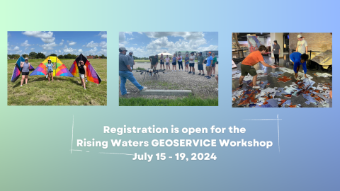
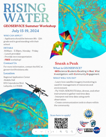
Rising water is shaping the future of Louisiana and the Gulf Coast. Explore the shifting physical landscape and how human activities must respond to them.
The event is hosted by LouisianaView and the Regional Application Center at the University of Louisiana at Lafayette
Who can apply?
Applicants should be between 8th and 12th grade and be in good standing with their school.
Details
• Monday through Friday from 9:00am 3:30pm
• Lunch is provided.
• Provide your own transportation
• Workshop is FREE!
How do I register?
Follow the link or scan the code below.

What does GEOSERVICE mean?
Geoscience Students Excelling in Real Vital Investigations with Community Engagement.
GEOSERVICE is earth observation technology in interdisciplinary projects that address environmental and public challenges that confront our society and future generations. GEOSERVICE matches industry partners and program participants to better prepare students for career paths in geosciences, geology, environmental sciences, coastal studies, natural disaster monitoring, and more.
More about the GEOSERVICE Grant
UL Lafayette’s Regional Application Center (RAC), headed by Brent Yantis, has been granted $364,874 by the National Science Foundation (NSF). The RAC specializes in satellite and remotely sensed imagery for developing earth resources applications. It collaborates with agencies such as NASA and the U.S. Geological Survey to provide the public with data. The grant aims to enhance interest in geosciences, particularly in geographic information systems technology. UL Lafayette’s faculty members, undergraduate, and graduate students will lead a bridge program that will reach out to high school students, thanks to this grant.
The aim of this bridge program is to cultivate curiosity in STEM professions, particularly in the fields of science, technology, engineering, and mathematics. The workshops concentrate on concerns that affect various communities in Louisiana, as well as the entire Gulf Coast. These concerns include coastline subsidence, marsh, and coastline erosion and retreat, and flooding due to tropical storm surges, heavy rainfall events, and sea-level rise. The program also addresses the human aspect of these issues. By participating, students acquire investigation and communication skills to disseminate information to their respective communities on how to address these problems.
What are some career paths in Geosciences?
- Health and Air Quality
- Disaster Response
- Water Resources
- Ecology/Earth Observation
- Urban Development
- Environmental Impact
- Food Security and Agriculture
- Energy
- Transportation and Infrastructure
Questions?
For more information, please contact us at geoservice@louisiana.edu.